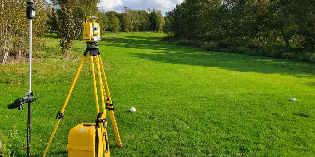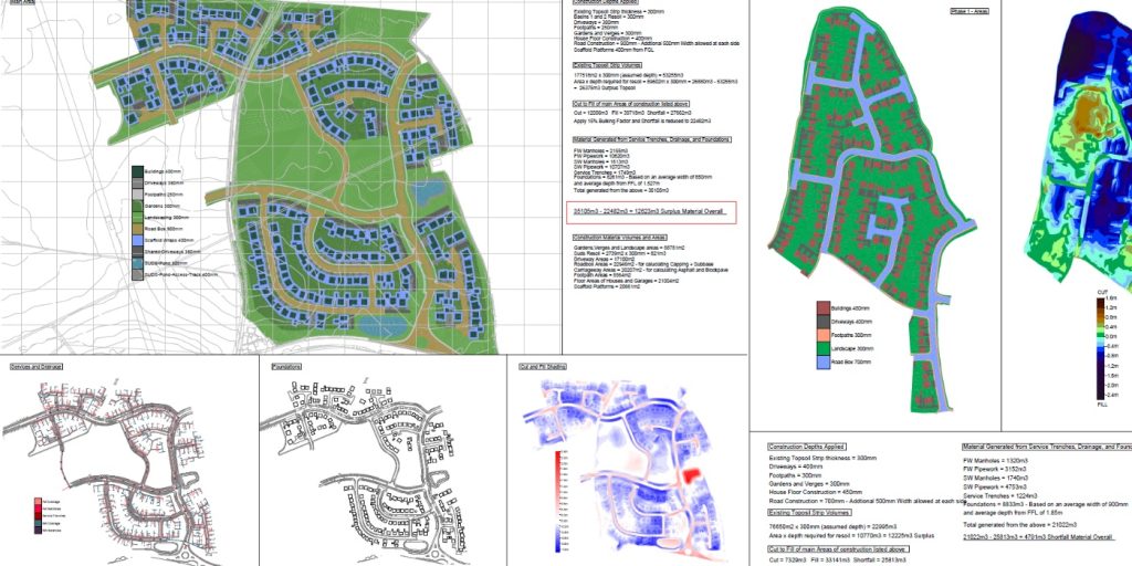


Drone Surveys, what are the benefits ?
Using drones to survey enable us to carry out topographical surveys in a fraction of the time that it would if we were using the traditional methods.
Capturing the data with the drone provides us with highly accurate and comprehensive results and as the trusty Total Station only measures individual points, one drone flight can produce thousands of measurements which we can represent in various different formats.
Post processing the data gathered we can then produce detailed elevation models, point clouds, contour lines as well as 3D reconstructions of buildings and sites for our clients.
This recent project shows the stages from cut and fill through to the finished design levels.
@tritechsurveys
@sitesurveyingservices
@djiglobal
#uav #drone #pointcloud #sitesurvey #constructionsite #topographical #landsurveying
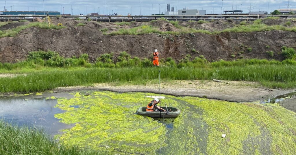
Its been an extremely busy week so far at @tritechsurveys both on site and in the office. We are currently working on some ongoing stockpile analysis using N4ce Applications in Cadd for one of our lovely clients. The results so far are looking fantastic.
If you have any volumetric requirements please feel free to drop us an email to see what we can do for you.
@tritechsurveys
@sitesurveyingservices
@appsincadd
#applicationsincadd #n4ce #volumetric #stockpiles #analysis #siteanalysis #survey #site #constructionsite
Gauge Board Survey
Last Autumn we surveyed some borehole locations for one of our clients.
They recently installed some surface water gauge boards and asked us to return to assist with the exact m aOD (metres above ordinance datum) and also the Easting and Northing of each board.
Thankfully the rain didnt return to stop play and we could access them all with ease.
@tritechsurveys
@sitesurveyingservices
#watergauge #watersurvey #landsurveying #waterlevels #topography #surveylife
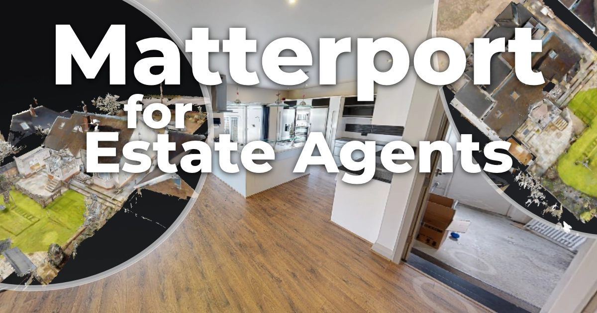
Do you need to showcase your business or venue ?
If so at @tritechsurveys we are now offering Virtual 3D tours.
Staying ahead of your competitors in the everchanging world of Marketing is a priority and our Virtual 3D tours are the perfect way in which to do this.
Our skilled team utilises cutting edge cameras and technology to capture the full essence of your space and we deliver high quality, detailed and virtually stunning results.
Pop over to our website or give us a call to have a chat about what we can do to take your space to the next level.
https://virtualtour3d.co.uk/
Office - 01347 833261
@tritechsurveys
@sitesurveyingservices
#virtualtours #digitalmarketing #media #3dvisualization #marketing #surveying #matterport
Exciting times for us here at @tritechsurveys , time for a Spring clean and office revamp.
This has made a positive change and boosted creativity, increased production and improved both team morale and communication.
This year we are also aiming to increase our company efficiency and looking to make @tritechsurveys carbon neutral, more details to follow.
Its definitely the small changes that can make the biggest impact on a business.
@tritechsurveys
@sitesurveyingservices
#officelife #productivity #dreamteam #positivity #surveylife #landsurveyor
Day out at the seaside town of Whitby.
Topographical survey and Utility survey completed on a site with some amazing views of the ruined Gothic abbey on the East cliff.
@tritechsurveys
@sitesurveyingservices
@trimblegeospatial
#utilitysurvey #topography #surveyor #yorkshire #whitby #whitbyabbey #dracula
Winner winner chicken dinner!
The winning entry to our in house Easter competition was The Calcutta Egg Cup.
Well done to @nathanharrap for his imaginative entry and very deserving of his gift voucher of choice.
Hope you all had a fantastic weekend!
@tritechsurveys
@sitesurveyingservices
#eastereggs #easter #competition #team #creative #teamfun #surveyinglife
The Easter Bank Holiday has finally arrived and we are all looking forward to a long weekend and eating our bodyweight in chocolate.
This year we decided to have a bit of Easter fun in house and have an egg competition. Getting those creative juices flowing, we managed to get some great entries.
Who`s your winner ???
Happy Easter Everyone, and remember Easter Eggs have NO calories 😂
@tritechsurveys
@sitesurveyingservices
#eastereggs #easter #competition #team #creative #teamfun #lifeofasurveyor
So far its been a busy busy week, carrying out a large Utility survey and Topographical Survey at Teesworks.
The team overcame lots of challenges with the high volumes of traffic in the work areas along with some dense vegetation.
A heroic thanks to our team for putting in the extra effort the get the surveys completed on time and also calling an ambulance for a gentleman who took very poorly at the roadside.
We are not just surveyors, we are life savers.. 🚑
@tritechsurveys
@sitesurveyingservices
#firstaid #lifesavers #gpr #utilitysurveying #topographical #whatateam
Another Day, another manhole..
Manhole surveys are an essential part of any construction project, allowing the relevant parties the learn exact route and nature of the existing site drainage.
Thankfully these were not some of the
` smelly ` ones we have come up against 😲
@tritechsurveys
@sitesurveyingservices
#manhole #manholesurvey #sonde #drainage #survey
National Surveyors week honours the importance of work that surveyors do.
Surveying is the foundation of every engineering project and the work that they provide subsequently shapes our communities.
From ensuring accuracy of developments and land use to setting out property boundaries and mapping roadways.
Surveyors are undoubtedly at the forefront of the Geospatial community.
You could say we are the `fifth` emergency service !
@tritechsurveys
@sitesurveyingservices
@surveyassoc
#nationalsurveyorsweek #landsurveyors #topography #utilitysurvey #construction #buildenvironment
A trip to Beverley, East Yorkshire to successfully complete a topographical survey of these vast beautiful gardens.
Utilising the @djiglobal M300 and the @trimblegeospatial total stations we produced some amazing deliverables.
Maybe we should `branch` out into the garden design business... move over Alan Titchmarsh and Charlie Dimmock, make way for Team @tritechsurveys
@tritechsurveys
@sitesurveyingservices
@trimblegeospatial
@djiglobal
#deliverables #clientsatisfaction #topographical #uav #design #gardendesign #landsurveyors
Yesterday @tritechsurveys attended the Apprenticeship Roadshow and Business Expo at Thirsk School and Sixth Form College.
This annual event gives opportunities to network and connect with local businesses and give an insight into apprenticeships that are available locally.
Our current apprentice, Callum Bate came along with us to share with some of the students and their parents about how he has progressed and found life as a budding apprentice surveyor.
These events are vitally important as they show the key role that apprenticeships have within a business and how they help grow our future workforce.
@tritechsurveys
@sitesurveyingservices
@thirsk6form
@thirskbusiness
#apprentice #business #surveying #networkingbusiness #college #landsurveyor
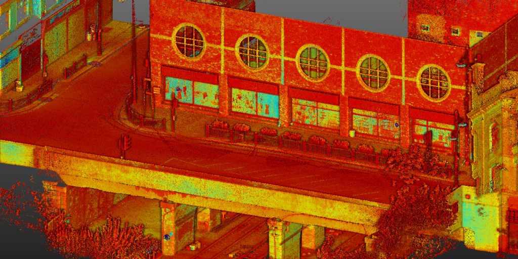
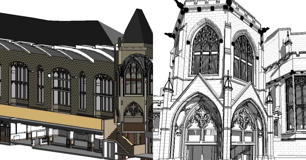
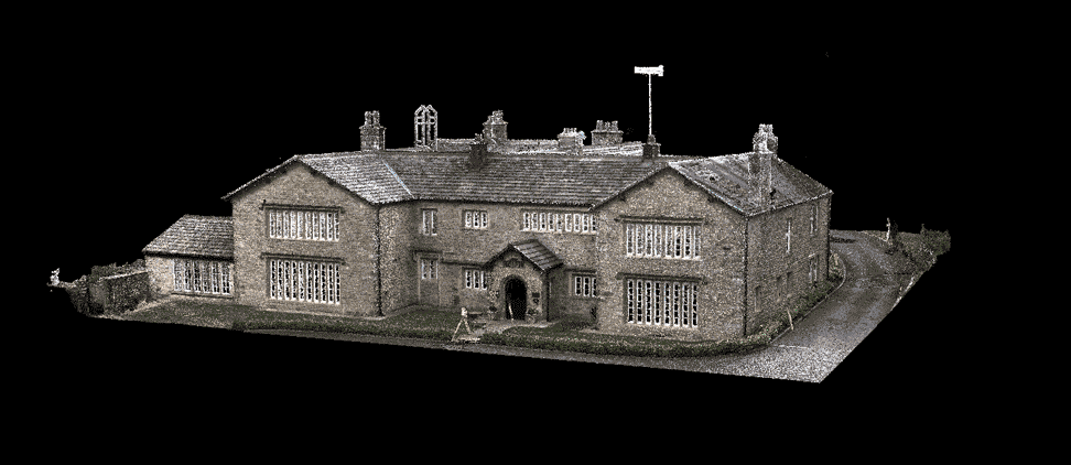
There was no muddy feet when we did the data collection on this site.
A full scan of the property inside and out including the back yard was required.
Here are a few of the deliverables from our visit to sunny Darlington.
If you have any surveying requirements get in touch with our team.
info@tritechsurveys.com
@tritechsurveys
@sitesurveyingservices
@the_survey_association
#measuredbuildingsurveys #survey #topography #site #landsurveyor #engineeringsurveying
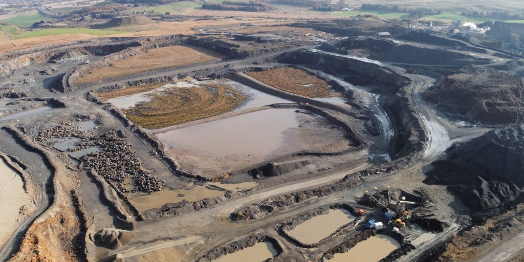
Using the @djiglobal M300 to fly the full site area. The data gathered is used to update the stockpiles and quarry measures.
This vast quarry is a regular haunt for our UAV team @tritechsurveys, as we have been visiting since 2018 keeping out client up to date with all site measurements.
@tritechsurveys
@sitesurveyingservices
@djiglobal
#uav #site #measures #data #drones #landsurveyor #siteengineer
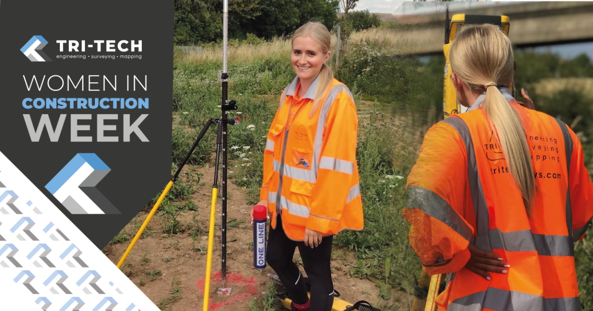
WOMEN IN CONSTRUCTION WEEK
This week we are celebrating the women who work in the construction industry. Here @tritechsurveys we are lucky to have a young woman who is excelling in our industry.
@tritechsurveys
@sitesurveyingservices
@_izzy_rickaby30
#womeninsurveying #womeninconstructionweek #womeninconstruction #surveying #surveyor #engineering #construction
Today was a bit of an adventure when our Trimble Geospatial X7 landed on the helipad at James Cook Hospital in Middlesbrough.
Using spheres and the leap frog method we laser scanned the area to provide ground levels of the helipad itself.
Needless to say our team had their ears and eyes open at all times just in case the barriers went up and they had to vacate very very quickly. 🚁🚁
@tritechsurveys
@sitesurveyingservices
@trimblegeospatial
#laserscanning #sphere #survey #urbandevelopment #jamescook #middlesbrough
There was no stopping @_izzy_rickaby30 when she went to Cumbria recently.
A fantastic topographical survey in the bag and some great action shots.
She is definitely living her best surveyor life. 😊
@tritechsurveys
@sitesurveyingservices
@trimblegeospatial
#surveylife #surveyor #lifeasasurveyor #landsurveyor #site #engineering #topographical
A well rounded week for all our teams at @tritechsurveys.
Venturing across the country, using a wide range of skills we completed various topographical, utility and monitoring surveys.
With a break in the weather and using Lidar we also took flight to re-measure stockpiles for one of our clients.
All in all a very productive week.
@tritechsurveys
@sitesurveyingservices
#workgoals #surveylife #survey #nationwide #landsurveyors #teamwork
A break in the weather and our team managed to get airborne to complete a full site UAV survey of all stockpiles.
This is a development we visited back in September and we returned to re-measure for our clients.
From the resulting data, volumes will be calculated for each stockpile.
@tritechsurveys
@sitesurveyingservices
#uav #stockpiles #data #dronephotography #dji #landsurveyinglife
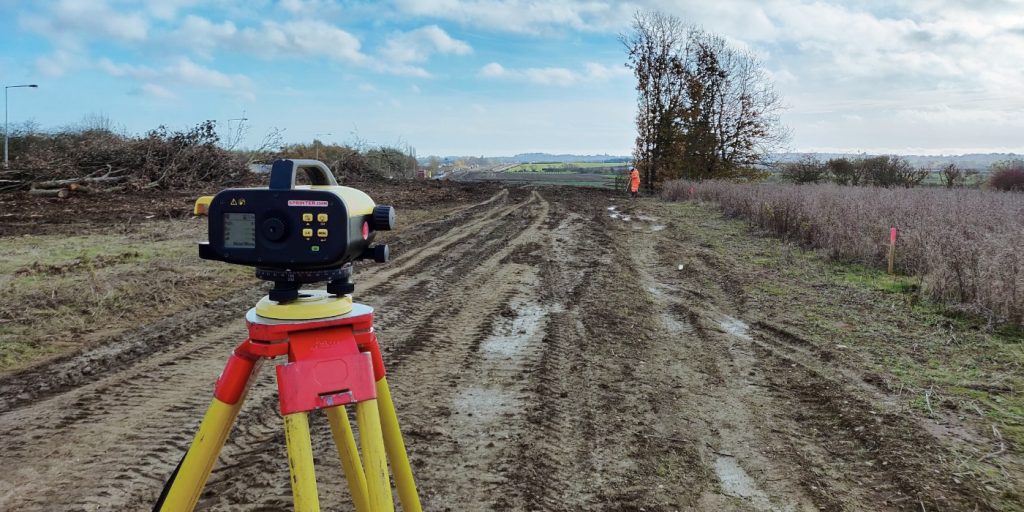
Three stages of levelling.
Surveying is a profession which has been around for thousands of years and the tools of the trade have evolved over time.
We were lucky to have some antique surveying instruments in the office today.
Shows how far survey kit has developed, most definitely a blast from the past.
@tritechsurveys
@sitesurveyingservices
#surveyequipment #levelling #landsurveying #blastfromthepast #surveyor #engineering #antiques
Heading out and about, hoping that the recent bad weather did not alter the watercourse and limit the surveys extents.
We completed the topographical survey on a 10 metre grid surveying the water levels top and bottom, a large drainage pipe outlet and also focussing on the eroded embankment of the river which our clients were keen for us to include in our survey.
Some beautiful views in a very wet Cumbria
@tritechsurveys
@sitesurveyingservices
#topography #siteengineer #landsurveyor #wetandwindy #watercourse #trimble
Out on what we can only describe as the most beautiful country home in East Yorkshire. Completing a detailed topographical survey of the gardens using the drone and traditional survey methods. It was a pleasure to spend our working day in this vast open plan office.
@tritechsurveys
@sitesurveyingservices
@trimblegeospatial
#trimble #uav #drone #topographical #surveyor #mapping #landsurveyor #outonsite
Welcome to Team Tri-Tech Jake.
Jake has joined us as an engineering surveyor. He brings with him years of experience in the civils sector and is sure to be an asset to the team, 😊
@tritechsurveys
@sitesurveyingservices
#newteammember #welcome #surveylife #surveyor #landsurveyor #construction
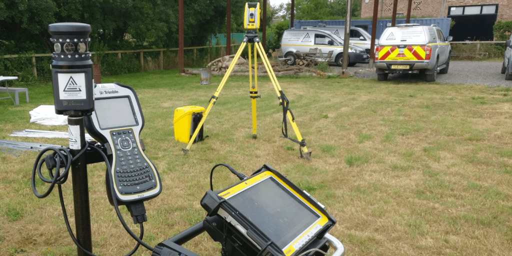
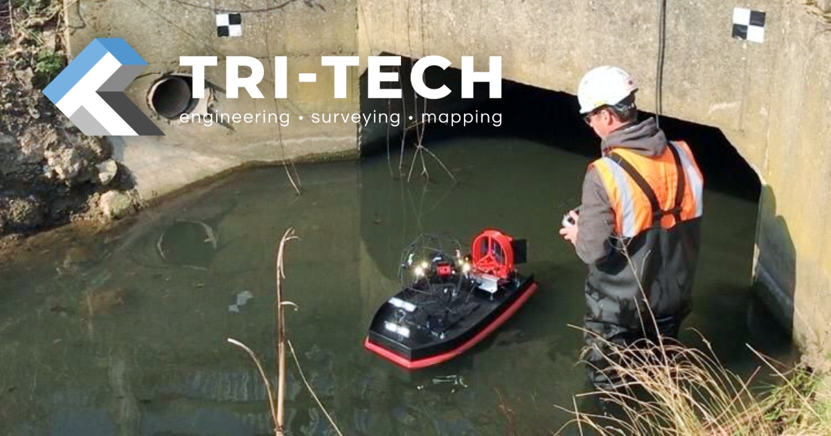
The main purpose of this Utility survey was to determine the foul sewer which headed East from the manhole in the entrance.
Using GPR and EML methods we established the presence of the existing drainage so our clients could
possibly tie into this when they develop the site
@tritechsurveys
@sitesurveyingservices
#sonde #eml #gpr #utility #survey #landsurveyor #sitedevelopment