


 Leeds
Leeds Doncaster
 Sheffield
 Bradford
 Hull
Hull Halifax
 Sunderland
 Newcastle
 Middlesborough
 Yorkshire Moors
 Teesside
 Cumbria
 Harrogate
 Teesdale
 York
York Yorkshire Dales
 Northumberland
 Goole
Goole Carlisle
 Keswick
 Kendal
 Barrow-in-Furness
 Lancaster
 Blackpool
 Morecambe
 Southport
 Liverpool
 Wigan
Wigan Manchester
 Blackburn
 Burnley
 Forest of Bowland
 Oldham
 Chester
 Stockport
 Peak District
 Skipton
 Crewe
Crewe Rotherham
 Stoke
Stoke Driffield


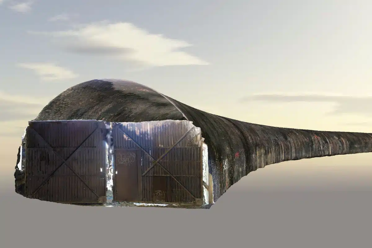
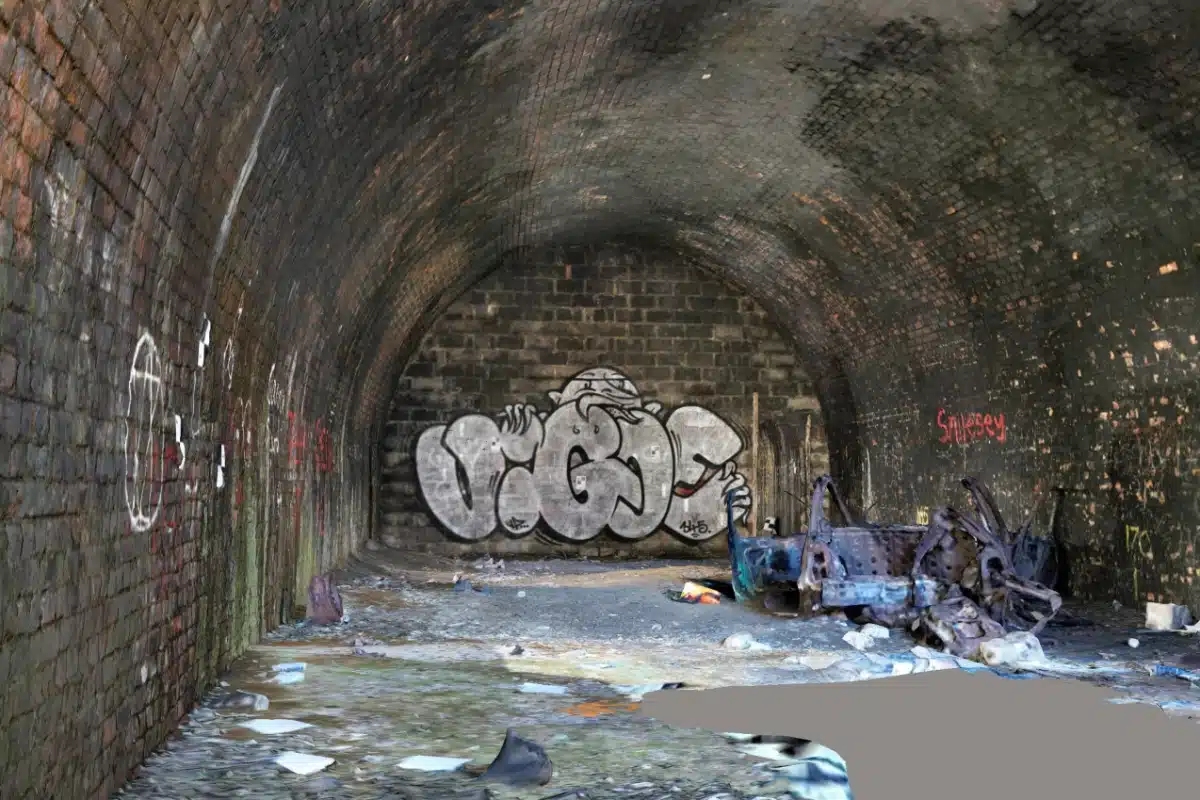
Lambton Staithe Tunnels & 3D Inspection Model
Project Overview:
As part of a major inspection and maintenance programme, our client required a high-accuracy 3D inspection model of the Sunderland Tunnels, along with supporting survey data to guide future works.
The project has three tunnels: one measuring 30 metres in length, a second at 100 metres, and a third at 174 metres. Each tunnel had its own unique challenges in terms of size, condition, and accessibility – demanding a flexible and robust survey approach.
Our Brief:
Our role was to create a complete digital record of the tunnels and surrounding site, supporting the client’s inspection, planning and future design works. The key requirements included:
- Control and target installation, establishing a reliable framework using GPS, a total station, and a traverse kit.
- A Topographical survey of the surface and access areas
- A complete 3D inspection model, created using photogrammetry, laser scanning and drone capture.
- Geo-referenced outputs are accurate enough to serve as a baseline for condition assessment, future comparisons, and potential design work.

Challenges
Surveying the tunnels in Sunderland required careful planning due to a number of site-specific challenges:
Confined Spaces
Working underground meant that health and safety protocols were critical. Strict confined-space procedures were followed, including ventilation checks, continuous monitoring, and specialist PPE.
Low visibility
The tunnels were heavily blackened with soot, making light ineffective and forcing our team to adapt to capture methods for low-light conditions.
Complex lengths:
With the tunnels varying from 30m to 174m, capture methods had to be flexible enough to ensure complete coverage, whether short confined surveys or extended traverses.
Access Constraints
Equipment setup and movement were restricted, requiring careful sequencing of operations to avoid delays or data gaps.

Our Approach:
To overcome these challenges, we employed a hybrid survey methodology that combined the strengths of multiple technologies. We established a reliable survey control framework, then combined above-ground and underground capture techniques to build a complete digital record of the tunnels.
Special attention was given to confined space safety, low-light conditions caused by soot, and the varying tunnel lengths, which demanded different equipment to wholly survey the site. We combined drone flights and laser scanning to accelerate capture.
The blended approach allowed us to maximise efficiency while delivering clarity and resolution needed for inspection purposes. By leveraging the strengths of multiple technologies, we achieved comprehensive coverage of each tunnel’s geometry, despite the challenging conditions.
Results & Impact:
The outcome was a detailed 3D inspection model, supported by topographical and survey control data, which provides the client with a powerful tool for planning and decision-making.
The model allows engineers to:
- Inspect tunnel geometry and condition without repeated physical access
- Monitor changes and potential structural deterioration over time
- Plan maintenance and future works more safely and cost effectively.
This project highlights the importance of pairing innovative technology with experienced surveyors in complex environments. Despite the challenges of confined spaces, poor visibility and safety restrictions, our team delivered a high-precision 3D inspection model that will serve as a vital resource for future planning and asset management.
Beyond the immediate project, this work reflects a much wider need across the UK: as infrastructure ages, detailed and accurate survey data becomes critical to ensure safety, efficiency and long-term sustainability. By harnessing tools such as laser scanning, photogrammetry and drone technology, surveyors can transform how we inspect, maintain and ultimately safeguard essential assets.
At its core, this project demonstrates how advanced surveying is more than capturing data; it’s about creating clarity where it’s most needed, helping engineers and asset managers make smarter, safer decisions for the future.