Land and engineering surveyors based in Yorkshire
Topographical Surveys
Trust Tri-Tech
Topographical Surveys Yorkshire
Accurate Topographical Survey Services Across the UK
Tri-Tech Surveys provides high-accuracy topographical surveys for planning, design, and construction projects across Yorkshire and the wider UK. Our detailed land and terrain surveys capture all natural and man-made features, delivering precise data you can rely on for informed decision-making. Whether you’re preparing a planning application, designing infrastructure, or developing land, our experienced surveyors deliver clear, compliant, and reliable topographical survey outputs tailored to your project requirements.
What is a topographical survey?
A topographical survey is a detailed measurement and mapping of a site’s physical features and ground levels. It records both natural features such as contours, trees, and watercourses, and man-made features including buildings, roads, boundaries, and drainage. Accurate survey data reduces risk, improves design efficiency, and ensures compliance with planning and regulatory standards.
What we capture
Our topographical survey services
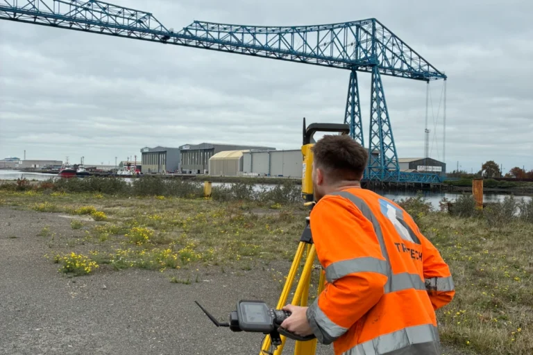
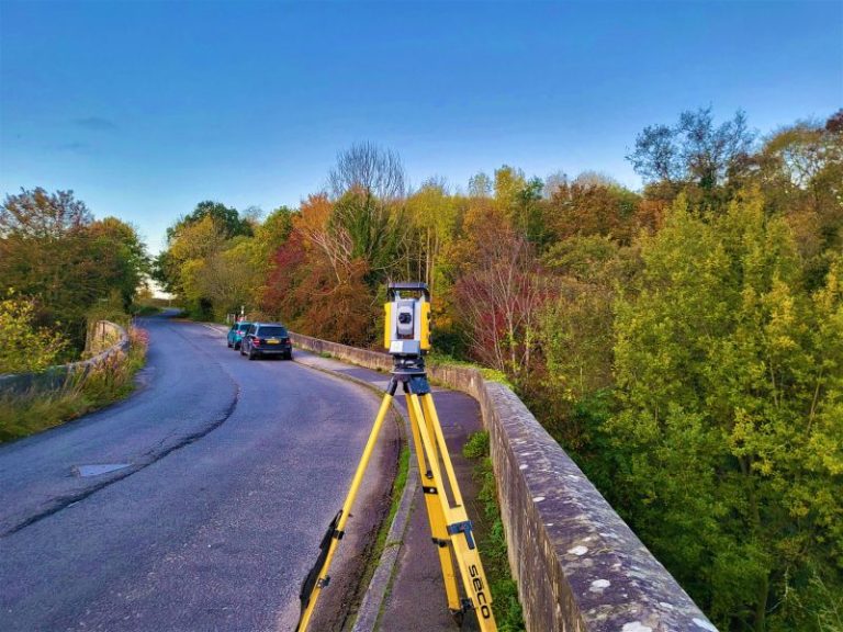
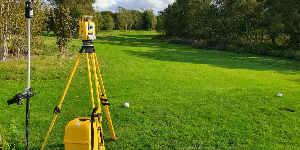
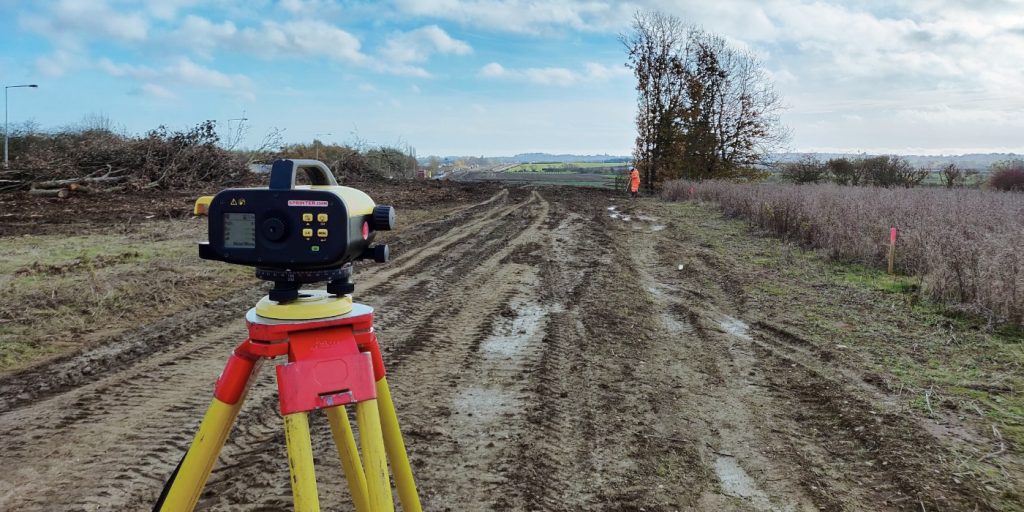
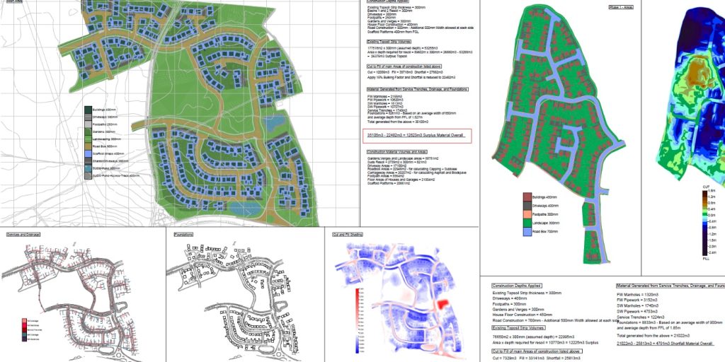
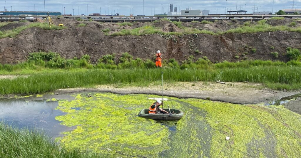
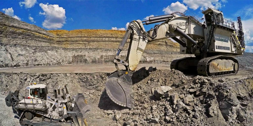
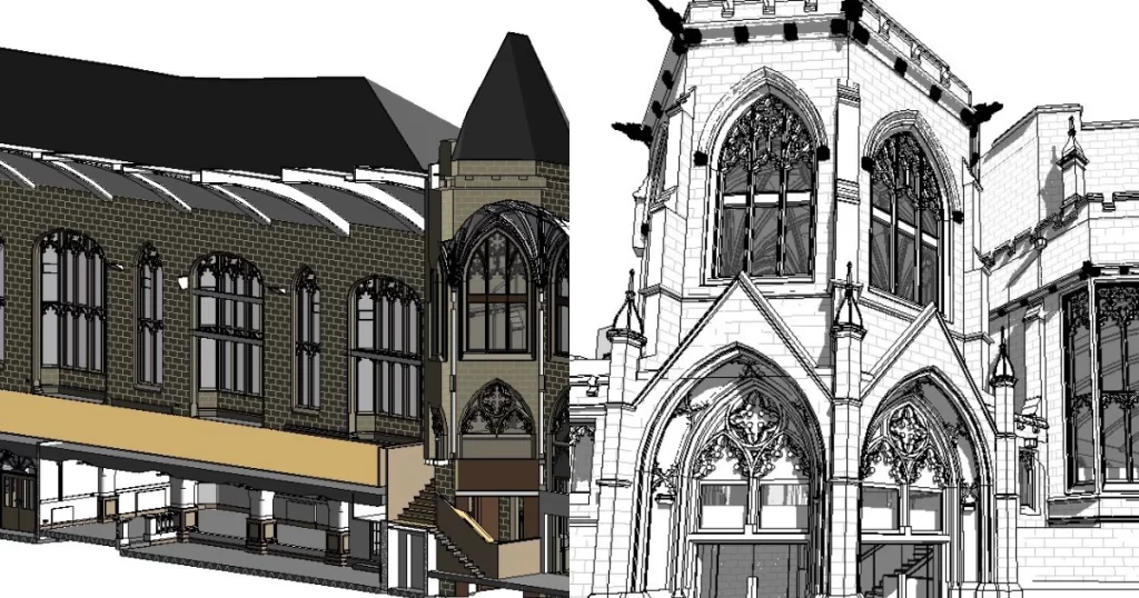
A topographic survey — also referred to as a land survey or topo survey — produces a detailed, accurate record of the physical features of a site. Ground levels, contours, boundaries, drainage, vegetation, structures, services at surface level and all contextual features within and around the survey area are captured and plotted to produce a georeferenced dataset that your design team can build on with confidence.
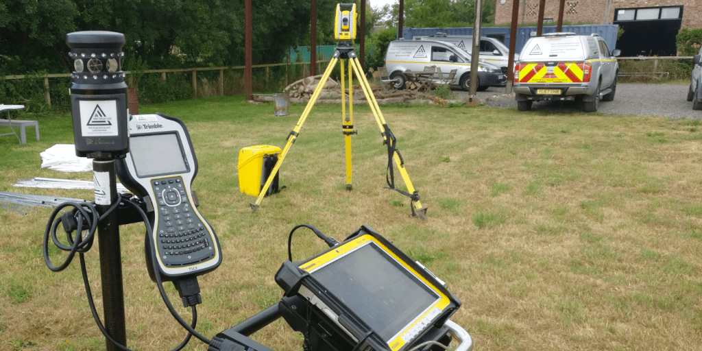
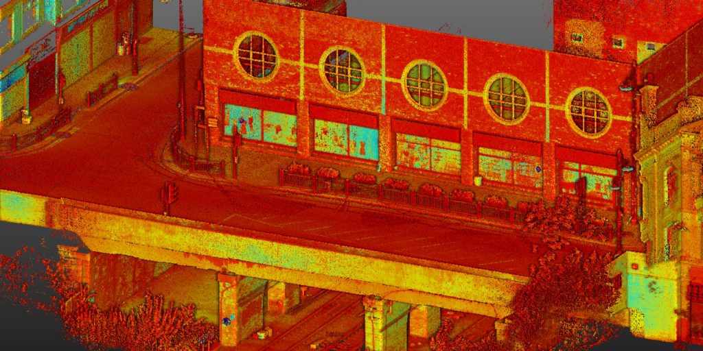
At Tri-Tech, we go beyond the industry standard on every survey we deliver. Sections, contours and intensity ramps are included as standard. Springs, subsidence, bodies of water and flood risk indicators are noted on every drawing. Where a 2D plan is not sufficient for the design brief, we produce 3D models, point cloud datasets and aerial overlays that give your project team a complete, measurable picture of existing conditions.
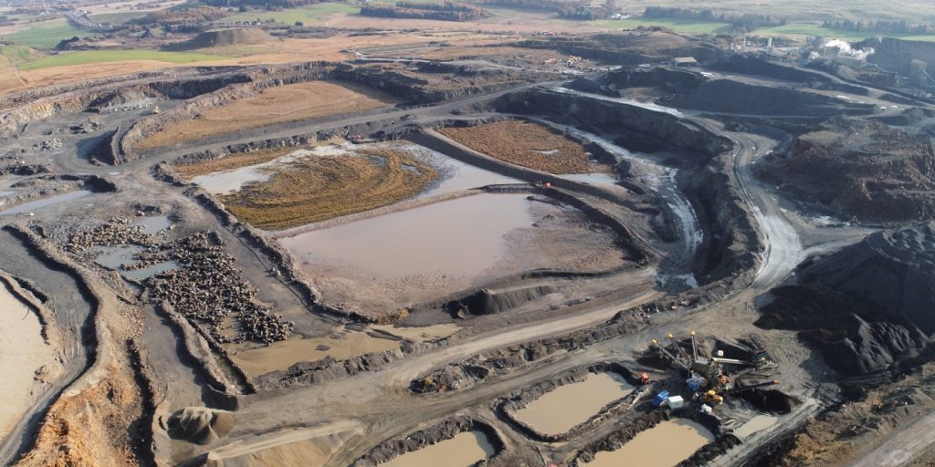
Every survey is OS-controlled, tied to National Grid, and delivered in the format your design software requires — AutoCAD DWG, Revit, GIS-compatible output, or a combination. In 2025 alone we completed over 950 topographic surveys across infrastructure, highways, regeneration and development schemes. The team that quotes your project is the team on site.
We believe that land surveying goes beyond mere measurements. To enhance our deliverables, we leverage the latest technology to provide additional features such as sections, contours, and intensity ramps throughout the site, all at no extra cost. Our drawings encompass a thorough documentation of all notable elements and limiting factors, including springs, subsidence, bodies of water, and more. At Tri-Tech we take pride in going above and beyond to ensure that our clients receive a comprehensive and detailed survey that meets their specific requirements.
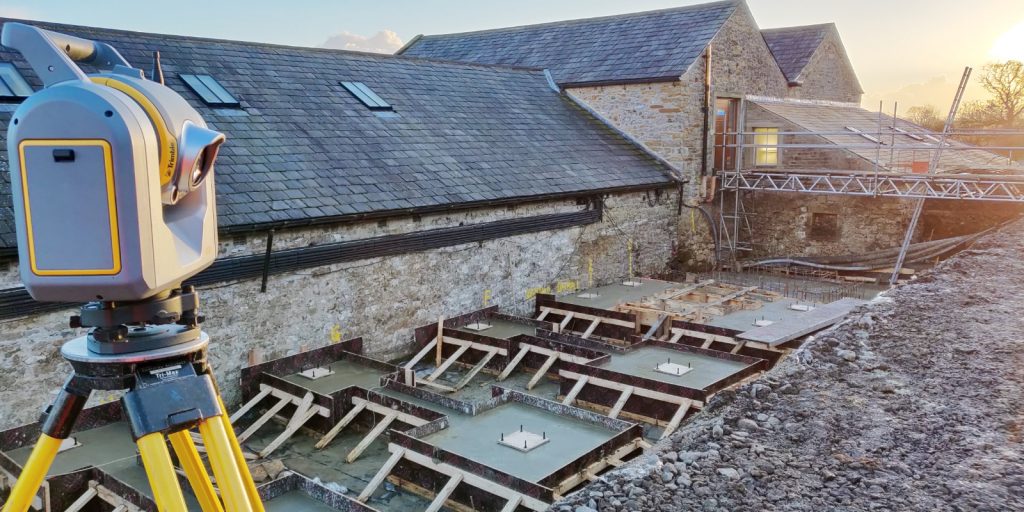
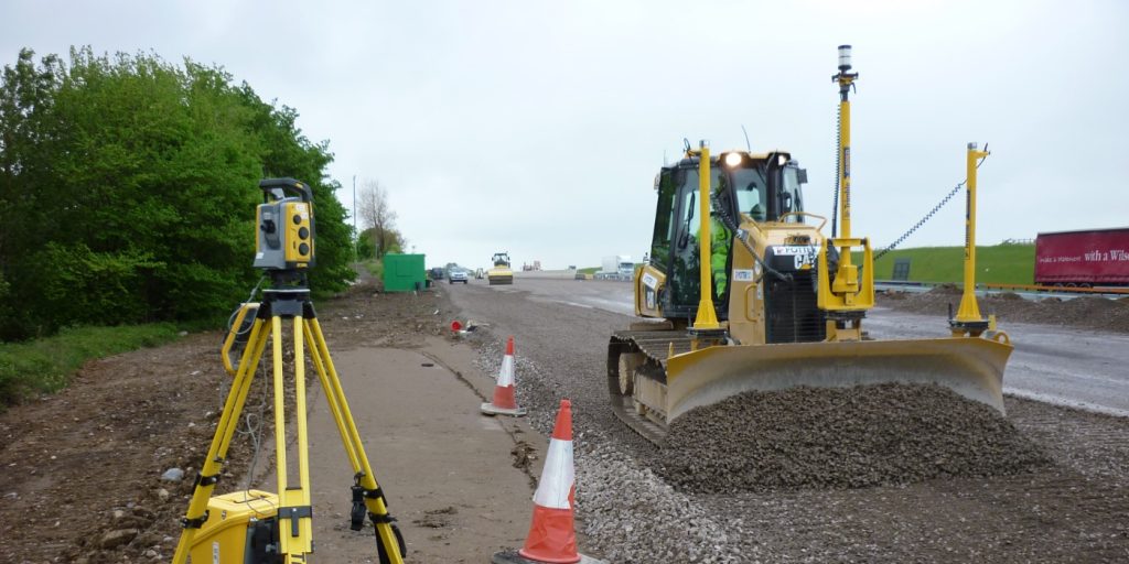
All features are surveyed to the accuracy specified and delivered with a clear methodology statement confirming the equipment used, the coordinate system, the accuracy achieved and the date of survey. Using Trimble and CHCNAV instrumentation, our surveys are precise, efficient and consistent across the most challenging North East and Yorkshire environments.
Ground Levels & Spot Heights
A comprehensive grid of verified ground levels across the survey area, to the density your design requires.
Contours
Generated from the level data, at intervals specified for your project.
Boundaries
All visible boundary features including fences, walls, hedges, ditches and ownership boundaries where determinable.
Drainage
Surface drainage features, gullies, manholes, channels and watercourses within the survey area.
Vegetation
Trees with canopy spread, species and height where required; hedges, shrubs and ground cover.
Structures
All above-ground structures including buildings, retaining walls, kerbs, steps, ramps and highway furniture.
Services at Surface
Visible service indicators including manhole covers, inspection chambers, meter boxes and duct markers.
Contextual Detail
Adjacent features, road levels, footway widths, overhead features and anything else that informs the design brief.
Why Do You Need
A Topographical Survey?
A topographical survey gives you a comprehensive view of your site’s layout and condition.
Who Commissions Topographic Surveys From Us
Topographic survey sits at the start of almost every construction, infrastructure and development project we work on. The clients who commission them include:
Tier 1 & Tier 2 contractors
Pre-construction topographic surveys for highways, civils and infrastructure programmes across Yorkshire, the North East and nationally. Kier and BAM Nuttall are already in our client list. We understand programme timescales and deliver without the chasing.
HIGHWAY ENGINEERS & CONSULTANTS
Corridor surveys, junction surveys and infrastructure surveys across the Highways England Area 12 and 13 supply chains. Active transport routes, road improvement schemes and major North East civils programmes.
Architects & Design Consultants
Feasibility and pre-application surveys for architectural projects across Yorkshire and the North East. We produce data structured for immediate use in your design environment, in the format your practice works in.
Property developers & housebuilders
planning consultants
OS-controlled, georeferenced survey data that supports planning submissions and is fully defensible if challenged.
Sports & leisure operators
We have delivered detailed topographic surveys at Premier League football club training grounds, sports facilities and leisure estates across the North East and Yorkshire.
Environmental & flood risk consultants
Topographic data for flood risk assessments, drainage design, Environmental Impact Assessments and river management schemes. We have worked with the Environment Agency and Lead Local Flood Agencies across Yorkshire on erosion monitoring and flood management programmes.
lAND SURVEYING SERVICES
Topographical Surveys for Your Sector
We provide flexible outputs to suit architects, engineers, planners, and contractors:
What Will You Receive from a Topographical Survey?
DRAWINGS (DWG/DXF)
PLANS
TERRAIN MODELS
PLANS
CONTOUR PLANS & LEVEL DATA
(Formats compatible with MX GENIO and other design software)
our Topographical survey case studies
Newcastle Airport - Airside Topographic Survey
Topographic survey carried out airside at Newcastle Airport — one of the most operationally demanding survey environments we work in. Precision planning, security clearance, strict site protocols and active runway operations as the backdrop. Survey data delivered to the accuracy and timescale the programme required, without incident.
Topographical Mapping of Tees Transporter Bridge
Tri-Tech were commissioned to deliver a comprehensive point cloud survey, full topographical mapping, UAV aerial LiDAR and bathymetric survey capturing the bridge including the land on both sides of the river in order to create a complete, digital dataset suitable for structural analysis, design coordination and future modelling.


Survey Technology & Methodology
Tri-Tech Surveys uses modern, proven surveying methods to achieve exceptional accuracy. Our approach ensures fast turnaround times without compromising on quality. We believe that land surveying goes beyond mere measurements. To enhance our deliverables, we leverage the latest technology to provide additional features such as sections, contours, and intensity ramps throughout the site, all at no extra cost. Our drawings encompass a thorough documentation of all notable elements and limiting factors, including springs, subsidence, bodies of water, and more. At Tri-Tech we take pride in going above and beyond to ensure that our clients receive a comprehensive and detailed survey that meets their specific requirements.
Benefits of a Topographical Survey
our services
How Topographic Surveys Integrate With Other Services
Topographical Surveys
OS-controlled accurate, efficient and cost effective surveys for highways, civils and development. Cad and BIM-ready output.
PAS 128 UTILITY MAPPING
Providing the location of underground services in 2D or 3D through qualified utility mapping surveys, using advanced GPR and Electromagnetic Location.
measured building surveys
Delivering accurate as-built information that supports design, refurbishment, planning and construction with the latest technology. Producing reliable drawings and digital models.
Laser Scanning
3D laser scanners capture millions of points per second, creating a point cloud which enables the finer details and the physical site to be viewed remotely.
Mobile Mapping
For highway engineers, infrastructure managers, local authorities and contractors working on live road schemes, mobile mapping is now the standard for corridor surveys.
3D machine control
With decades of supporting major earthworks contractors and large-scale infrastructure schemes, we provide reliable machine control across Lancashire and the wider UK.
Setting out engineers
With strong, long-standing relationships across the civil engineering and construction sector, we supply skilled professionals who keep your projects accurate, efficient and on programme.
bathymetric surveys
stockpile surveys & volumetric analysis
Whether a one-off stockpile measurement or regular monitoring, we deliver reliable, repeatable data tailored to your project using advanced technology.
control network installation
Delivering robust and precise site control systems to support every stage of construction in developments, infrastructure schemes or major earthworks.
aerial & drone surveys
CAA-approved drone operations for aerial mapping, photogrammetry and volumetric analysis, providing a comprehensive view of terrain, structures and landscapes.
bim model creation
Whether you require an as-built Revit model, federated coordination model or detailed digital twin, our team delivers high quality, design-ready outputs.
survey equipment hire
We offer a vast range of surveying and engineering equipment for hire and will always try to beat a comparable quote. Discover the fleet.
monitoring
Providing reliable monitoring surveys across the UK, delivering precise data that supports risk management, compliance and informed decision making throughout a project lifecycle.
virtual tour 3d
An immersive experience which instantly transports your clients to your business, guiding them through your space and creating a seamless experience.
We pride ourselves on delivering precision data you can trust, supporting projects of all sizes from initial planning through to construction.Our highly skilled surveyors provide:
In choosing the right scanning method for your project
3D data capture and processing
Clear and client-ready deliverables
Throughout your entire project
Frequently Asked Questions
What is a topographical survey?
A topographic survey is a detailed measured record of the physical features of a site — ground levels, contours, boundaries, drainage, vegetation, structures and all relevant features within the survey area. It is produced to a specified accuracy and delivered as a georeferenced dataset for use in design, planning and construction. A topographic survey is more accurate and more detailed than an OS map — it is site-specific, produced to the tolerance your project requires, and tied to a coordinate and level system for immediate use in design and construction workflows.
How accurate is a topographic survey?
For most construction and infrastructure applications, topographic surveys are delivered to ±10–20mm accuracy on levels and ±20–50mm on planimetric features. Where higher accuracy is required — for setting-out control or structural design, for example — we can increase the specification accordingly. All our surveys are OS-controlled and tied to National Grid. We will confirm the accuracy specification at the time of quoting.
What is included in a topographic survey?
A standard Tri-Tech topographic survey captures ground levels, contours, boundaries, drainage, vegetation, structures, services at surface level and contextual detail. We include sections, contours and intensity ramps as standard. If there are site-specific features you require — springs, subsidence indicators, overhead features, adjacent building levels — tell us at the time of instruction and we will confirm what is included within the scope.
What file format will my topographic survey be delivered in?
We deliver topographic surveys in the format your design team requires — AutoCAD DWG, DXF, Revit, PDF plan and GIS-compatible formats are all available. Confirm your requirement at the time of instruction and we will build it into the deliverable spec before survey.
How long does a topographic survey take?
This depends entirely on the size and complexity of the site. A straightforward residential or small commercial site can typically be completed in a single day. A large industrial facility, highway corridor or multi-building campus will require longer. We will give you a realistic timeframe when we return your quote.
Do you survey in live environments — highways, airports, industrial sites?
Yes. Our team is experienced in working in live and operationally demanding environments — live carriageways, operational industrial facilities, active runways, underground tunnels and occupied buildings. We produce method statements to reflect site conditions and we hold the accreditations required for most restricted access environments. Our Teesport, Newcastle Airport and Sunderland tunnel projects are direct examples of this capability.
What is the difference between a topographic survey and an OS map?
An OS map is a generalised representation of the landscape produced at a national scale — typically 1:25,000 or smaller. A topographic survey is a site-specific, measured record produced to the accuracy and detail your project requires, at scales from 1:200 upwards. Features and levels that do not appear on OS mapping are captured and the data is tied to specific coordinate and level systems for direct use in design and construction.
Can you combine a topographic survey with other services?
Yes — and for most programmes we recommend it. Combining topographic survey with PAS 128 utility mapping, bathymetric survey, laser scanning or UAV data gives the design team a complete picture of the site in a single coordinated dataset. It is more efficient, more cost-effective and significantly reduces the risk of design-stage surprises. Tell us what your programme requires at the time of instruction and we will advise on the most effective combination.
Do you cover areas outside Yorkshire and the North East?
Yes. Tri-Tech operates nationally from offices in Ripon, Nottingham, Bedford and Glasgow. Our primary territory is Yorkshire and the North East, but we deliver topographic surveys across the full UK when the programme requires it. All work is delivered by our directly employed team.
North East and Yorkshire land surveyors.
Leeds
Doncaster
Sheffield
Bradford
Hull
Halifax
Sunderland
Newcastle
Middlesborough
Yorkshire Moors
Teesside
Cumbria
Harrogate
Teesdale
York
Yorkshire Dales
Goole
Carlisle
Keswick
Kendal
Barrow-in-Furness
Lancaster
Blackpool
Morecambe
Southport
Liverpool
Wigan
Manchester
Blackburn
Burnley
Forest of Bowland
Oldham
Chester
Stockport
Peak District
Skipton
Crewe
Rotherham
Stoke
Driffield