


 Leeds
Leeds
 Doncaster
 Sheffield
 Bradford
 Hull
Hull
 Halifax
 Sunderland
 Newcastle
 Middlesborough
 Yorkshire Moors
 Teesside
 Cumbria
 Harrogate
 Teesdale
 York
York
 Yorkshire Dales
 Northumberland
 Goole
Goole
 Carlisle
 Keswick
 Kendal
 Barrow-in-Furness
 Lancaster
 Blackpool
 Morecambe
 Southport
 Liverpool
 Wigan
Wigan
 Manchester
 Blackburn
 Burnley
 Forest of Bowland
 Oldham
 Chester
 Stockport
 Peak District
 Skipton
 Crewe
Crewe
 Rotherham
 Stoke
Stoke
 Driffield

A nationwide surveying and engineering company operating in both the public and private sectors.

Read about our Surveying Services, which include Topographical Services, Utility Mapping and Monitoring Campaigns.

We have created some answers to a series of questions which explains a little more about our services.
Head Office
North West Office
Glasgow Office
Bedford Office
Bedford Office
As part of a new housing development in Ilkley, Tri-Tech was commissioned to deliver a full package of infrastructure surveys, combining topographical, utility mapping, and CCTV drainage investigations.
Our goal was to provide developers and design teams with complete, high-accuracy data to inform construction, utilities planning, and drainage design, creating a clear, reliable foundation for all subsequent stages of work.
Located along a busy main road and active bus route, the project required careful coordination to ensure safety, minimise disruption, and deliver all data correctly the first time.
The project began with a detailed pre-site planning phase to align traffic management logistics with the client’s programme and the local council’s requirements.
To keep the project on schedule, our survey team worked collaboratively with traffic management specialists, implementing phased bus lane closures while maintaining access for local traffic.
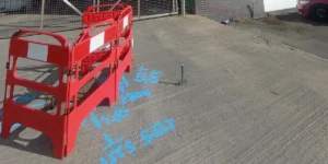
Conducted during the day to eliminate the need for night closures, this survey captured all above-ground details including kerbs, carriageway lines, boundaries, surface materials, and site levels.
Using a combination of electromagnetic location and ground-penetrating radar (GPR), our surveyors mapped all existing buried services, from telecoms and power to gas and water, providing precise georeferenced data across the full survey zone.
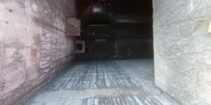
Using a CCTV drainage inspection unit, our team accurately captured the information for assessing the condition of onsite drainage, providing a comprehensive report.
By coordinating all three survey types through the same in-house team, we ensured total consistency, efficiency, and confidence in the results.
Surveying in a live traffic environment presented several operational challenges:
Maintaining safety while capturing detailed surface and subsurface data
Managing multiple survey types across restricted working areas
Avoiding rework or return visits due to limited access windows
Our project management team worked proactively with both the council and the client to:
Secure timely permits and coordinate traffic management with minimal disruption
Use phased survey methods to keep works progressing safely
Leverage a single, consistent field team, ensuring the same high-quality data across topo, utility, and drainage deliverables
This integrated approach meant all required data was captured first time, saving time, reducing costs, and allowing design teams to move forward with complete confidence.
The final deliverables including detailed topographical drawings, PAS 128 utility mapping plans, and CCTV drainage reports gave the client a comprehensive, single-source dataset for design and planning.
By combining above-ground and below-ground surveys, we enabled a seamless design process, reduced project risk, and ensured the infrastructure design was built on accurate, verified information.
This project highlights Site Surveying Services’ capability to deliver multi-disciplinary surveys in complex environments while maintaining safety, precision, and efficiency.
This project reflects our commitment to delivering data-driven certainty for complex infrastructure and housing developments. By combining multiple survey disciplines – topographical, utility mapping and drainage – into one coordinated package, we helped our client move from planning to design with confidence, accuracy and minimal disruption to the community.
Our consistent team, proactive communication and careful management of live-traffic conditions ensured the project was completed safely and efficiently and on schedule. From busy urban roads to rural developments, Site Surveying Services continues to provide the clarity beneath every decision – supporting better, safer and more sustainable outcomes for clients across the UK.