Cutting Through the Noise: The Different Types of Laser Scanning and What They Deliver
Laser scanning has become one of the most powerful tools in modern surveying. But while many people have heard of it, fewer truly understand the different types of laser scanning available – or how each one can transform raw environments into actionable data.
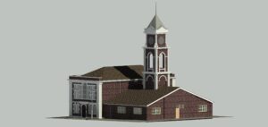
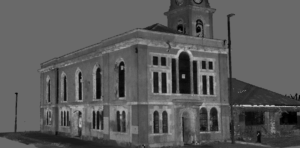
The ‘Tripod Scanner’ that most people picture when they hear the term terrestrial scanning. Mounted in a static position, these scanners capture a 360 sweep of its surroundings by firing millions of laser pulses per second. These pulses reflect off surfaces and are recorded as data points, building up a dense point cloud of the environment.
Advantages
Unmatched accuracy; millimetre precision across static or semi-static sites.
Ideal for capturing fine architectural or structural detail
Produces datasets robust enough for heritage preservation and BIM workflows
Unlike static terrestrial scanners, SLAM scanners are more mobile and can be handheld or mounted to other equipment. Using this scanner, surveyors are able to walk through a space while continuously scanning, due to continuous positioning recalibration that builds a live 3D data set.
Advantages
Speed - entire buildings or overgrown areas can be captured in a fraction of the time
Works in complex, obstructed or confined spaces (tunnels, industrial plants, etc)
Flexible - can we used both indoors and outdoors
Outputs
Rapid point clouds
As-built 3D models for facilities or asset management
Quick surveys for planning or renovation projects
UAV/ Drone based Laser scanning (LiDAR)
LiDAR sensors mounted on UAVs fire pulses of light towards the ground, measuring the time it takes for the signal to return. By repeating this thousands of times per second while the drone flies over, the system builds a highly accurate model of the landscape.
Advantages
Coverage at scale - perfect for large, open or inaccessible sites
Penetrates through vegetation to map the bare earth beneath
Reduces risk by capturing data from the air instead of putting surveyors in hazardous terrain
Outputs
Extensive point clouds
Digital Terrain Models (DTMs) and Digital Surface Models (DSMs)
Volumetric analysis e.g. stockpiles, excavation progress
Our expertise lies in operating these tools, and knowing when to deploy each one or combine them. For example:
A heritage site might require TLS for millimetre-precise detail on facades, supplemented by SLAM for interior corridors.
A Quarry may benefit from UAV LiDAR for overall coverage, tied into a TLS control network for ultimate accuracy.
A city redevelopment could integrate all three methods to create a complete, multi-layered data set.
The outputs are as diverse as the methods themselves: from BIM-ready models and measured survey drawings to terrain maps and volumetric calculations, laser scanning gives clients the confidence that every decision is grounded in data.
Laser Scanning is rewriting how we plan, preserve and build. But the real value isn’t just in the technology, it’s in choosing the right approach for the right project. By tailoring our methodology, we give clients the clarity they need to plan confidently, save time, reduce risks and ultimately deliver projects that succeed.
Download our laser scanning & Measured building survey Brochure


 Leeds
Leeds Doncaster
 Sheffield
 Bradford
 Hull
Hull Halifax
 Sunderland
 Newcastle
 Middlesborough
 Yorkshire Moors
 Teesside
 Cumbria
 Harrogate
 Teesdale
 York
York Yorkshire Dales
 Northumberland
 Goole
Goole Carlisle
 Keswick
 Kendal
 Barrow-in-Furness
 Lancaster
 Blackpool
 Morecambe
 Southport
 Liverpool
 Wigan
Wigan Manchester
 Blackburn
 Burnley
 Forest of Bowland
 Oldham
 Chester
 Stockport
 Peak District
 Skipton
 Crewe
Crewe Rotherham
 Stoke
Stoke Driffield